How GNSS Receivers Empower Smart Cities

Latest GPS module technology for automation and machine control
By 2050, more than 60 percent of the world's population is expected to live in urban areas. Cities are facing this rapid rise in population while also confronting the effects of climate change, economic restructuring, ageing populations, and pressures on public finances. Therefore, it is essential to make large cities more sustainable, efficient, and livable whilst ensuring safety, security, and health.
Many technologies are already available or under development to help make this possible. Sensors and reporting systems monitor a wide range of events from traffic flows to water leaks, from air pollution to energy consumption, from crime reports to parking volume. These various data sets are supplemented by crowd-sourced inputs, as residents flag potholes or construction noise through their smartphones, while cars, home appliances, and all sorts of other connected devices (collectively known as “the Internet of Things”) automatically collect and relay still more data in the background.
Information and communication technologies store, analyze, and display “big” data, which local governments can use to manage assets and resources more efficiently while also becoming more transparent, interactive, and responsive. Cities that systematically deploy these technologies to connect every layer, from the air to the street to underground, to improve the lives of their citizens and communication with them are known as “smart cities.”
Why Location Accuracy Matters
People want to know not just when something is happening but also where. Fortunately, an increasing proportion of just about every piece of data in a smart city is tagged with its spatial coordinates, which are collected mostly by global navigation satellite systems (GNSS) receivers. GNSS receivers—from low-precision ones in smartphones and car navigation systems to high-precision ones used for professional applications—play an essential, though unseen, role in improving life in a smart city.
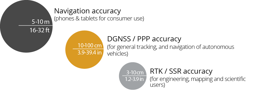
Location accuracy requirements can vary significantly depending on the application: an autonomous vehicle’s positioning system needs to be accurate within about 10 cm (four inches) to keep it safely within its lane on the highway, and engineering projects such as road and utility construction require solutions with better than 2.5 cm (sub-inch) accuracy.
Today and Tommorow
Today, when a bulldozer or a grader is grading a new road surface, or a concreting system is putting down the final surface on a new highway, a high-accuracy GNSS machine control system enables it to do so faster by telling it exactly where to lower its blade to achieve the desired surface grade. In the future, many semi and fully automated vehicles will drive around cities, guided by GNSS receivers in addition to cameras and LIDAR. Due to their driverless nature, the ability of those GNSS receivers to perform accurately and reliably every time will be critical to ensuring safety for passengers and pedestrians alike.
Multi-frequency GNSS receivers able to track all available constellations, including Europe’s Galileo and China’s BeiDou, are more reliable, and faster than those that can only track the United States’ GPS and Russian GLONASS. The capability of tracking all GNSS satellites in view is especially important in challenging environments such as urban canyons (between skyscrapers), where all-constellation receivers might see 14 to 20 satellites and the older GPS/GLO receivers only see six to eight.
An Exercise of Accuracy
Sky plots show the value of multi-constellation GNSS receivers:
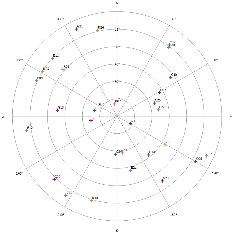
Septentrio AsteRx open sky plot, at Leuven, Belgium, 21-Jan-2019 at 11:21 UTC tracking 30 GNSS satellites. The HDOP value (Horizontal Dilution of Precision, indicative of the effect of geometry on horizontal position accuracy) is 0.47 in this case.
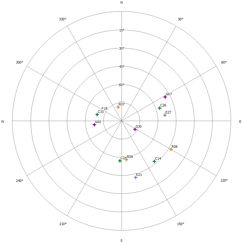
Septentrio AsteRx highly obstructed sky plot, at Leuven, Belgium, 21-Jan-2019 at 11:19 UTC still tracking 13 GNSS satellites. The HDOP value is 1.66 in this case, which is still very good.
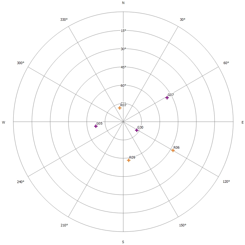
Other GNSS manufacturer only receiving GPS/GLONASS with highly obstructed sky plot, at Leuven, Belgium, 21-Jan-2019 at 11:20 UTC only tracking 6 GNSS satellites. The HDOP value is 2.40 in this case.
Why Robustness Matters
Besides urban canyons, city environments pose another challenge to GNSS receivers: unintentional radio frequency (RF) interference from cell phone towers, especially 4G and LTE, radio communication systems, and the ever-increasing number of electronic devices appearing in smart cities. Additionally, all GNSS receivers are at risk of intentional interference from illegal jammers. Therefore, GNSS receivers need to be not only accurate but also resilient to RF interference wherever they operate.
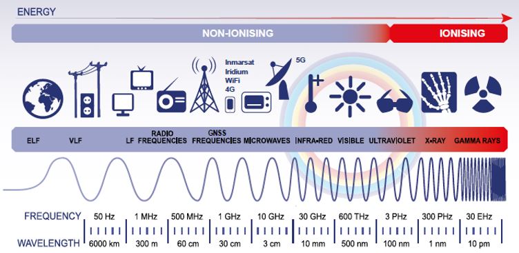
RF spectrum, packed with many possible RF interferers such as 4G LTE, 5G, WiFi, Bluetooth, and VHF signals.
RF interference with GNSS receivers can be particularly disruptive for transport networks, such as those tracking public buses. In most bigger cities, large numbers of people rely on regular and safe public transportation to travel to work, rail stations, social activities, or sports events. Most bigger public transit agencies now use GNSS receivers in buses to track their location in real-time, then display their position on a map in the control center and their expected arrival times on digital displays at bus stops. When interference (intentional or not) affects the typical GNSS receivers utilized on busses, the result is the loss of information to the extent that the control center will not be able to know where to locate the bus, hence passengers waiting for the bus will not know when it is meant to arrive.
Why Reliable Communications Matter
Communications networks, such as cellular and broadband, are the arteries of the data of smart cities and are essential to positioning, navigation, and timing systems in three main ways. First, they facilitate the transmission of augmentation data from Continuously Operating Reference Stations (CORS) to GNSS receivers. Second, they transmit real-time information on construction work, traffic, vehicles, etc. to navigation systems. Third, they relay the actual GNSS positions measured on vehicles back to centralized tracking and monitoring centers, in order to support the real-time scheduling of public transport and the like.
However, communications systems are vulnerable to RF interference, too. Making GNSS positioning systems resilient to telecom outages requires other means of transmitting the precise augmentation data over alternative communications links, including terrestrial radio, cellular, and WiFi, or potentially using satellite-based communications approaches such as Precise Point Positioning (PPP) or Satellite-Based Augmentation Systems (SBAS) via L-band signals.
GNSS Infrastructure
CORS, operated by government agencies, universities, and private companies, are a critical part of the infrastructure of smart cities. They provide data for real-time corrections and post-processing that enable 24/7 centimeter-level Real Time Kinematic (RTK) GNSS collection for all types of surveying, mapping, construction, and engineering activities, as well as for autonomous vehicles and unmanned aerial vehicles (UAVs). Smart cities use UAVs for many different activities, such as traffic monitoring and police surveillance. Centimeter-level accuracy greatly expands how they can use the still imagery, video footage, or LIDAR data that the UAVs collect.
Four Ways GNSS Receivers Can Help Smart Cities
Resilience to Interference. Government agencies—especially those responsible for mapping, telecommunications, and transportation—and GNSS network providers report that interference is one of the main vulnerabilities of GNSS and that, therefore, more resilience is needed. Over the last 20+ years, Septentrio has been perfecting its AIM+ (Advanced Interference Mitigation) technology into all its GNSS receivers. Septentrio’s Interference Monitoring should become a standard part of public and private GNSS infrastructure. Download our free 20 pages interference brochure and also our GPS spoofing brochure to explore the topic of GNSS interference jamming and spoofing further.
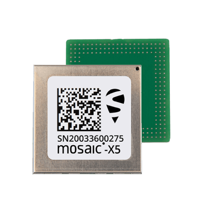
Asset Tracking. There is a growing need across all markets for efficient and reliable ways to track assets and support real-time location-based services (LBS). Asset tracking increases efficiency (it’s easier to deploy assets if you know where they are), deters theft, reduces disputes with customers, and enhance employee safety. Septentrio's mosaicTM, a multi-band, multi-constellation receiver in a low-power, surface-mount module with a wide array of interfaces, is optimal for asset tracking, as well as for emergency vehicles communicating with smart traffic lights turning green when they approach an intersection. It tracks all GNSS constellations, supporting both current and future signals, and features a unique built-in AIM+ technology for interference mitigation.
Industrial Internet of Things (IIoT). In many markets, reliable communication is still a huge challenge, and will continue to be as the number of M2M (machine-to-machine) interfaces grow. Septentrio provides core ASIC and IP to integrate highly robust and accurate positioning into all kinds of IIoT, allowing developers and integrators to concentrate on the communications challenges.
Position, Velocity, and Time (PVT) Authentication. Security and traceability of location is becoming critical for government and industry. However, there are currently few, if any, means of authenticating the output of solutions that provide the PVT of a vehicle or other asset being tracked. Open source geo-blockchains are increasingly being considered as a means to provide traceability and authentication for the output of PVT transactions, including the type of RTK corrections, network, datum transformation, and operator used, as well as the project, solution type, etc. Timing authentication is very important for many critical activities, including financial transactions and electricity transmission. GNSS signals are used to provide precise timing with every financial transaction – something that is critical in ensuring that all accounts are reconciled correctly. Cell phone towers also make use of GNSS-aided timing to ensure that the scheduling of data and voice packets is handled efficiently between adjacent cell towers. Electrical grid operators also use GNSS timing to assist with transferring huge amounts of current from distant power generation facilities over large distances into metropolitan areas. Efficiently and safely balancing the supply of sufficient power as a city’s demand changes through the day and night is critical—not just to ensure that customers get power when they need it, but to prevent damage to the electrical grid infrastructure through brown-outs or black-outs. Septentrio receivers include countermeasures against falsified signals (protecting against so-called spoofing) and are ready to support authentication features such as the upcoming Galileo Navigation Message Authentication (NMA) service.
Conclusion
The position accuracy of GNSS receivers will continue to improve as new and modernized GNSS constellations come on line, which will deliver greater accuracy in increasingly challenging environments. Nevertheless, providing robust, reliable, and accurate positioning will continue to require the integration of CORS, L-band, and multi-band GNSS frequencies, as well as interference monitoring. Septentrio’s GNSS receivers, which are multi-frequency, power CORS, and incorporate the company’s AIM+ technology, meet all of these requirements.