
Science meets adventure, on Nanok Arctic expedition
Posted on 25-05-2022
Image
Two Belgian adventurers are currently crossing Greenland on a triathlon including ski, kayak and a vertical rock climb. They have Septentrio’s AsteRx-SB receiver for the ride to collect valuable data for climate research in collaboration with the Royal Observatory of Belgium.
Leuven, Belgium – May 25, 2022 - Septentrio, a leader in high-precision GNSS* positioning solutions, is supporting climate research in conjunction with the Royal Observatory of Belgium by equipping two Belgian adventurers with the latest GPS/GNSS technology for collection of accurate positioning data. This data will help build a precise elevation profile of the Greenland Ice Sheet as well as to calibrate existing elevation models, which are based on satellite altimetry. In addition, the multi-frequency capability of the AsteRx-SB receiver will enable monitoring of the ionospheric activity as well as Galileo signals at high latitudes.
“The AsteRx-SB receiver provides accurate and reliable positioning data even in the world’s harshest environments. Data collected during this first-of-a-kind expedition will help research of arctic ice caps, ionospheric activity and other topics,” said Dr Nicolas Bergeot, Time-Ionosphere section of the Royal Observatory of Belgium.
The expedition is called Nanok, which is an Inuit word for polar bear. The adventurers, Gilles Denis and Nathan Goffart, started the triathlon with a 600 km of ski with a pulk sled along the Arctic Circle. The second part of the triathlon is a 1000 km sea kayak along the Greenland east coast, and finally there is a 1 km vertical rock climb for the opening of a new route. The AsteRx-SB receiver and the PolaNt-x MF antenna is accompanying the explorers for the whole journey. For more information about Septentrio receivers contact the Septentrio team.
* Global Navigation Satellite System including the American GPS, European Galileo, Russian GLONASS, Chinese BeiDou, Japan’s QZSS and India’s NavIC. These satellite constellations broadcast positioning information to receivers which use it to calculate their absolute position.

Figure 1: Two explorerr (see here their current location during their journey), equipped with Septentrio GNSS receiver are traversing Greenland and taking high-accuracy positioning measurements which will help with ice elevation and ionospheric activity research at high latitudes. Image credit: Google Earth.

Figure 2 The first part of the triathlon is a ski with a pulk sled across Greenland. Image credit: Nanok Expedition.

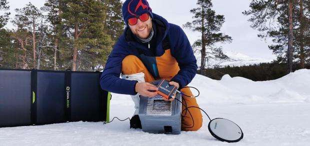
Figure 3 The AsteRx-SB receiver on the pulk sled will accompany the two explorers along their journey, so that data can be collected at various locations along the way. Image credit: Nanok Expedition.
About Septentrio:
Septentrio is an ISO 9001 certified manufacturer of multi-frequency multi-constellation GPS/GNSS positioning technology for demanding applications. Reliable centimeter-level positioning enables machine automation improving efficiency and safety. Septentrio provides positioning solutions for industrial applications such as robotics, construction, survey and mapping, maritime, logistics and unmanned aerial vehicles (UAVs).
Septentrio has its headquarters in Leuven, Belgium and has a world-wide presence with offices in Los Angeles, Shanghai, Seoul and Yokohama as well as numerous partners around the world. To learn more about Septentrio and its products, visit septentrio.com.
Related information:
- Insight article: GNSS in a Cold Climate
- Technology: IONO+ Ionospheric resilience
- Explorers' official website: www.nanokexpedition.be