4 Constellations in 1 RTK

In difficult conditions, multi-frequency, quad-constellation RTK can deliver over 40% more RTK availability than dual-constellation RTK
More satellites in RTK for those hard-to-reach areas
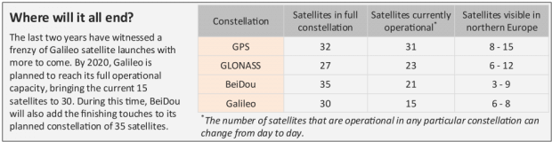
How many satellites do you need for precise and reliable RTK positioning? Evidence thus far suggests, the more the merrier. With this in mind and given that GPS and GLONASS are now at FOC (Full Operational Capacity) the only way to add more satellites to RTK is to add more constellations and this means the fledgling BeiDou and Galileo constellations.
A brief history of RTK
GNSS receivers are essentially devices that measure the distances to satellites known as pseudoranges, which they then use to calculate their own position. Back in the early 1980s, as well as using the code modulated onto GPS signals, researchers began to realise that the phase of the signal could also be exploited. The phase of a GNSS signal is basically a measure of satellite distances in terms of whole numbers and fractional parts of signal wavelengths. High-end GNSS receivers today are able to measure phase with a precision of 1/200th of a wavelength which, for the GPS L1 signal with a wavelength of 19 cm, means a distance precise to 2 mm. After folding in the various clock and orbit errors from satellites as well as signal delays in the atmosphere, the 2-mm precision on a single satellite pseudorange translates into a final RTK position precision of about 1-2 cm.
By the late 1990s, GLONASS was on the scene and was mature enough for a combined GPS + GLONASS RTK. The next to arrive was BeiDou with the first reported triple-constellation RTK in the mid-2010s. Last to the party was Galileo, with commercial multi-frequency, quad-constellation RTK receivers only now becoming available.
Will Galileo be the answer to all my GNSS dreams?
In open-sky, additional satellites add redundancy—always good for position integrity—but it’s only when obstacles start to appear on the horizon, blocking out parts of the sky, that all-in-view RTK really comes into its own. With limited sky visibility, GNSS users have either had to plan carefully beforehand so that their work coincided with high satellite visibility, or accept that they had reached the operational limits of their GNSS receiver and make do with alternative positioning methods. Using four constellations, RTK can now reach the parts that dual and even triple-constellation receivers feared to tread.
Image
Quad-constellation RTK in action
Figure 1 shows the difference in RTK availability when using four satellite constellations in RTK instead of two. The plot shows RTK fix percentages in the quad and dual-constellation cases as the elevation mask is increased. Data were collected in Leuven, Belgium (latitude: 50° 51ʹ N) over 24 hours in open-sky conditions using Septentrio rover and base station receivers. To mimic the effect of satellite masking, the original data was re-processed using the offline re-processing engine PP-SDK with different settings for the elevation mask.
With elevation masks of up to 35°, RTK availability is almost 100% in both cases. When visibility is good, the additional satellites won’t increase RTK availability, they will however produce a more robust RTK position with a lower DOP (Dilution of Precision).
When elevation masks of between 35° and 50° are simulated, the benefits of quad-constellation over dual-constellation RTK become clearer. Under these conditions, the inclusion of Galileo and BeiDou resulted in an average increase of 40% in the number of RTK epochs. Over the course of an 8‑hour working day, this translates into an average of 59 extra minutes of RTK.
When only satellites with elevations above 50° are visible, RTK availability becomes too low to be of any practicable use.
Image

Image
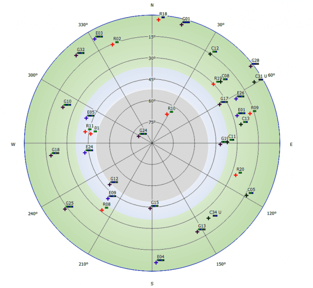
Figure 2: A sky plot showing a snapshot of satellites visible overhead during the 24-hour data collection. The shaded zones correspond to the elevation mask zones in Figure 1.
Septentrio has implemented quad-constellation RTK on its own receivers and many major European reference station networks also have quad-constellation GNSS receivers installed.
Download A4 print version of this insight