Predicting Crumbling Cliffs
How GNSS receivers help inspection in challenging environments
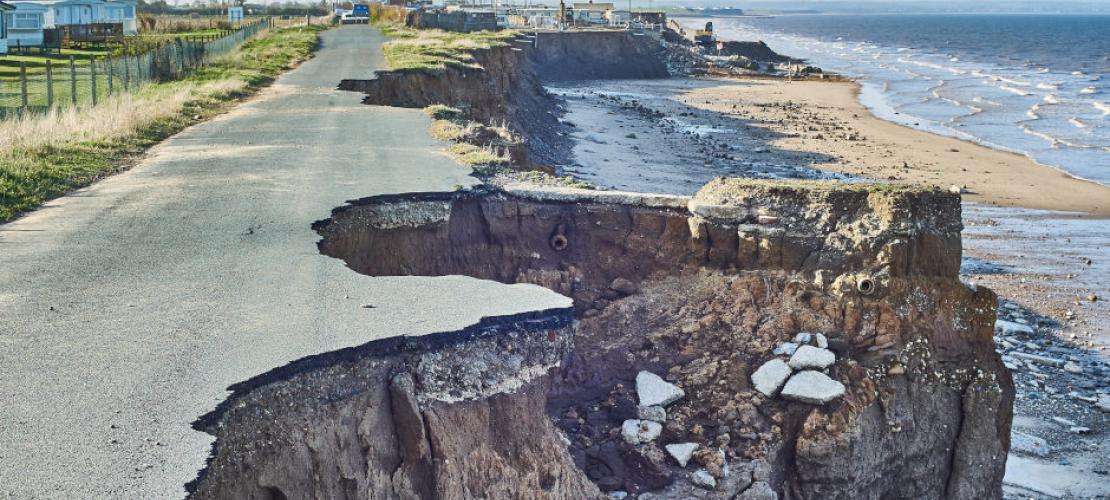
In 2012, nine homes in Happisburgh, an historic village on England’s Norfolk coast, had to be knocked down after the road on which they were built, started to crumble away into the sea. In July 2013, in St Jouin Bruneval, Normandy, an estimated 30,000 tons of rock split from the 50-meter-high cliffs near the French city of Le Havre and plunged onto the public beach below. In June 2016, huge waves and king tides eroded about 50 meters of the Narrabeen and Collaroy beaches in Sydney, Australia badly damaging waterfront properties and putting them at risk of toppling into the sea. This October, in East-Sussex, England, thousands of tons of chalk crumbled away from the Seven Sisters cliffs at Birling Gap, followed a few days later by another large cliff fall at Seaford Head.
Answers Urgently Needed
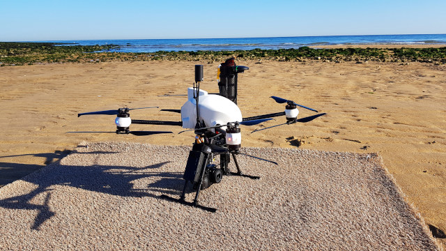
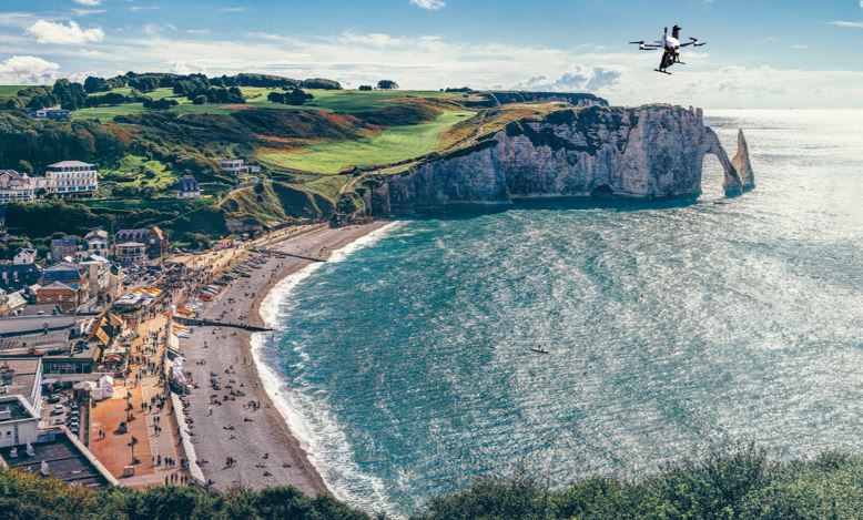
Researchers studying this erosion of coastal cliffs in Normandy needed to capture images of these hard-to-reach and unsafe landscapes. The operational challenges included strong winds, limi-ted time windows with optimal lighting, and safety concerns due to operating in an urban environment, which deman-ded high positioning accuracy. They turned to AltiGator, who equipped their OnyxStar XENA drone (UAV) with a Septentrio high-accuracy GNSS receiver and a Sony digital camera, to create the ideal airborne platform capable of collecting excellent results.
The Challenges
The process of erosion of coastal cliffs is slow and happens over a long time, however the actual cliff collapse is sudden and seemingly random. This complex dynamic makes it very hard to study and to determine the respective impacts of the many factors contributing to this erosion. Yet a thorough understanding of where and when cliff failures occur is essential for safety, especially near buildings, roads, and recreation areas, where landslides and rock falls can destroy property and injure or even kill people, in homes above the disaster or on beaches below it.
Acquiring this understanding requires data at high spatial resolution and with high refresh rates. Furthermore, measuring changes in an unstable and nearly vertical cliff face can be dangerous to the researchers, therefore in situ data are mainly collected by non-contact remote-sensing methods. The choice of sensing method depends on the geographic extent being studied, the spatial precision and refresh rate required, and the available budget. Various techniques are available for these remote sensing activities, including terrestrial mapping, aerial mapping, UAV lidar and UAV photogrammetry. For this project, UAV photogrammetry was the ideal choice as it could overcome the difficulty of accessing the cliffs.
A small UAV is a particularly safe, efficient, and cost-effective way to collect imagery on coastal cliffs. Researchers can easily transport and deploy the platform and then control the collection and monitor local conditions while remaining at a safe distance from the cliff they are studying.
Demanding Requirements
Researchers at the Center for Research on Coastal Environment (CREC) of the University of Caen, in Normandy, France, faced four major challenges:
- taking off from and landing on sand, in different weather conditions
- limited time windows to take advantage of the optimal and most constant light
- strong ocean winds and proximity to houses, which required high precision GNSS and interference mitigation to operate safely
- limited view of the sky due to the steep cliffs.
Additionally, CREC required that the UAV be
- certified by the French Civil Aviation Authority (because it would be operated close to buildings)
- versatile, meaning that the researchers needed to be able to change the photogrammetry sensor
- powerful enough to deal with strong winds, yet compact and portable
- able to collect data for post-processed kinematic (PPK) positioning, to precisely geolocate the photogrammetric imagery and compare it over time to monitor the erosion.
The Solution
To deal with these challenges and requi-rements, they hired AltiGator to build a rotary wing UAV. AltiGator modified an OnyxStar XENA compact, foldable octo-rotor UAV, which features a gimballed camera mount, and equipped it with a Septentrio GNSS board and a Sony multispectral camera to overcome all the challenges faced by the researchers.
The project’s requirements and constraints led to the selection of Septentrio’s AsteRx OEM board because of its reliable multi-frequency and multi-GNSS constellation measurements, which allow it to operate in topographies where other single- and dual-constellation receivers cannot function optimally. Its ultra-low power consumption helped the battery life to be more efficient while operating in a windy environment. Additionally, its integrated Advanced Interference Mitigation (AIM+) system guarantees the safety and availability of operations in busy urban environments.
For the mapping workflow, AltiGator used geotagging software which provided reliable centimeter-level RTK positioning without the need of Ground Control Points (GCPs).
Workflow
For this mission, CREC required PPK positioning because, for aerial mapping, it can deliver more reliability and longer range from the GNSS base station than real-time kinematic (RTK) positioning. While RTK positioning processes the data during the flight, PPK positioning logs data onboard the UAV and combines it with data from the base station once the flight is completed. PPK positioning therefore eliminates the risk of losing data or initialization due to radio link outages and allows the processing software to trace back and forth through the data multiple times to give more comprehensive results.
While flying its missions along the cliffs, the UAV took pictures and recorded the spatial coordinates of each image in a digital log. After the flight, these logs were processed in geotagging software, which improved positioning accuracy stored in each picture’s exchangeable image file format (EXIF). This greatly improves the speed and precision with which orthophotos are later built without the need of GCPs, which are impossible to place in these locations.
Use Of The Data
CREC provides data and advice to public institutions. For example, it might employ observations it has made to advise them on how best to build, maintain, and improve dams and then monitor those dams to check their performance. The CREC researchers were especially impressed with the spatial resolution and accuracy of the images of the cliffs that they were able to collect with the Septentrio positioned AltiGator system. These images will greatly assist them and public agencies in assessing the stability of the cliffs and identifying the more likely locations of failures, in order to prevent or reduce damage, injuries, and fatalities.
Click here to download the insight in pdf.